The Junkerhamn Rock - GC6KHK0
This is the story of the dramatic life of a rock, from a time more than 1600 million years before the first dinosaurs walked the Earth, all the way to the present. To log this EarthCache it may be good to bring something with which to measure height, as well as a magnifying glass.
Chapter 1 - 1.88 billion years ago
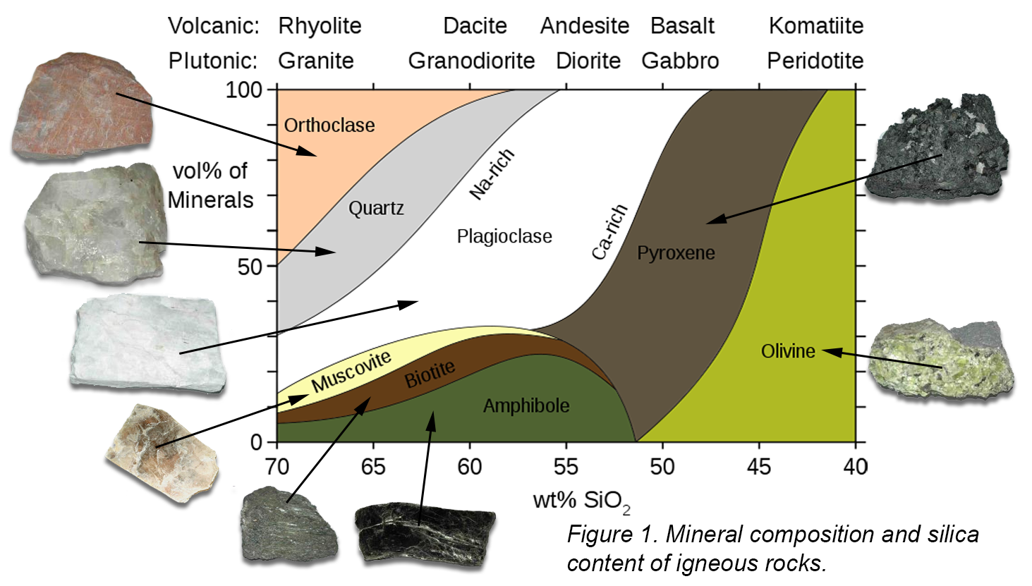
Our stone's formation deep within the earth was of intrusive character. Magma slowly pushed up through the lithosphere (crust and upper part of the mantle), cooling on the way which caused crystallization. The magma consisted of various minerals with different melting points, which caused the formation of a mixture of crystals. Since the pressure and temperature were relatively high, the crystallization was slow which resulted in a coarse-grained structure. The rock formed was a so called igneous plutonic rock, as contrary to volcanic extrusive rocks, which are cooled quickly which leads to a fine-grained structure.
Igneous rocks can be classified on the basis of mineral composition and cooling history. Figure 1 below shows a rough classification scheme. The stone here belongs to the so-called Haparanda suite of rocks, which consist of mafic (<52% silica, SiO2) or intermediate (52-65% SiO2) rocks.
During this time veins of aplite were also formed. Aplite is an intrusive igneous rock which filled up cracks in the surrounding rock.
Chapter 2 - 10,000 years ago
Scandinavia has been covered by ice on several occasions, most recently around 10,000 years ago. The ice sheet has had a major impact on the landscape. To our stone the ice age was a cataclysmic event, since the rock was dislodged and transported by the ice – the stone had become a glacial erratic.
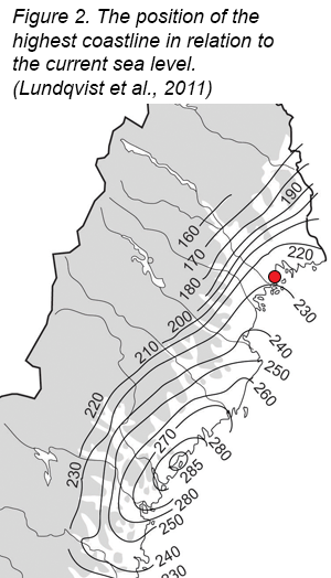
The weight of the three kilometer thick icecap depressed the Earth’s crust by as much as 800 meters below the original level. When the ice began to melt and the pressure was removed, the crust relatively quickly recovered to a large part (elastic response). Despite this, the sea level at the time of the ice’s withdrawal about 8700 years ago was around 230 meters higher than today in the area around Luleå (Figure 2 below) and our stone thus found itself resting deep below the ocean’s surface.
Chapter 3 - 600 years ago to present
The post-glacial rebound is still ongoing, and at the Norrbotten coast the annual uplift is around 9 mm per year. Around year 1400 the sea level had risen to the level that our stone almost had reached the surface. According to legend, birkarl Anders Junker and his three sons were at this time on their way home from a trade trip to Finland. At exactly this location, however, the trip came to an abrupt end when they literally ran into our friend the stone and sank. By foot they walked to Lakaviken, where they settled and became the first farmers of the village Sundom.
Today the Junkerhamn (“Junker Port”) rock rests entirely on dry land during normal sea level, and constitutes a characteristic landmark in the inlet to Sundom.
Questions
Send the answers to the questions below in Swedish or English to CO. You can log the EarthCache immediately, without waiting for approval. If something is amiss, I’ll contact you.
- It’s difficult/impossible to determine what type of rock a stone consists of by only studying it visually. However, you can make a rough guess, especially if you can find an area on the stone that isn’t too coated with contaminants. Look closely at the Junkerhamn Rock (preferably with a magnifying glass!) and try to identify various mineral crystals. Which mineral types can you see? Based on the diagram in Figure 1; what kind of rock do you think the stone is made up of?
- Study the aplite dikes. Describe their appearance and shape relative to the rest of the stone. What do you think is the reason for the difference? Can you see any grains or crystals in the aplite dikes? If yes, approximately what size, compared to the grains in the rest of the stone? What does this say about the crystallization speed of the aplite compared with the surrounding rock?
- On the basis of observations on site and the information given in the text: Approximately to which depth did the top of the stone reach at the time of the Junkers’ grounding, if the legend is true? Describe how you came to this conclusion.
Optional but appreciated: Take a picture of you and/or your GPS at the site!
Sources
Andréasson P-G (red.) (2015), Geobiosfären, en introduktion. Studentlitteratur.
Lundqvist J m.fl. (2011), Sveriges geologi från urtid till nutid. Studentlitteratur.
Upptäck Sundom 8, Junkerhamnsstenen. Tillgänglig på http://www.sundom.se/files/4968.pdf
Ödman O (1957), Beskrivning till berggrundskarta över urberget i Norrbottens län, SGU Ca 41. Sveriges geologiska undersökning.